Lighthouse View
Lighthouse View combines AIS data with automated shore-side camera captures worldwide — giving you visual proof of vessel movements, not just transmitted signals.
For those who cannot afford guesswork
With terrestrial, satellite, and ship-borne AIS, we have more signals from the maritime domain than ever before. But malicious actors have adapted, poisoning the well with deceptive data:
- Identity Theft: Vessels “resurrecting” the IMO numbers of scrapped ships or hijacking the identities of vessels still under construction.
- Phantom Movements: Sophisticated AIS spoofing that creates entire “ghost” voyages.
- Draught manipulation: Pretending to be in ballast while actually being fully laden.
Maritime intelligence analysts need access to a wide array of data sources to detect these activities. Lighthouse View provide the “eyes on the ground” you need to expose maritime misconduct.
How it works
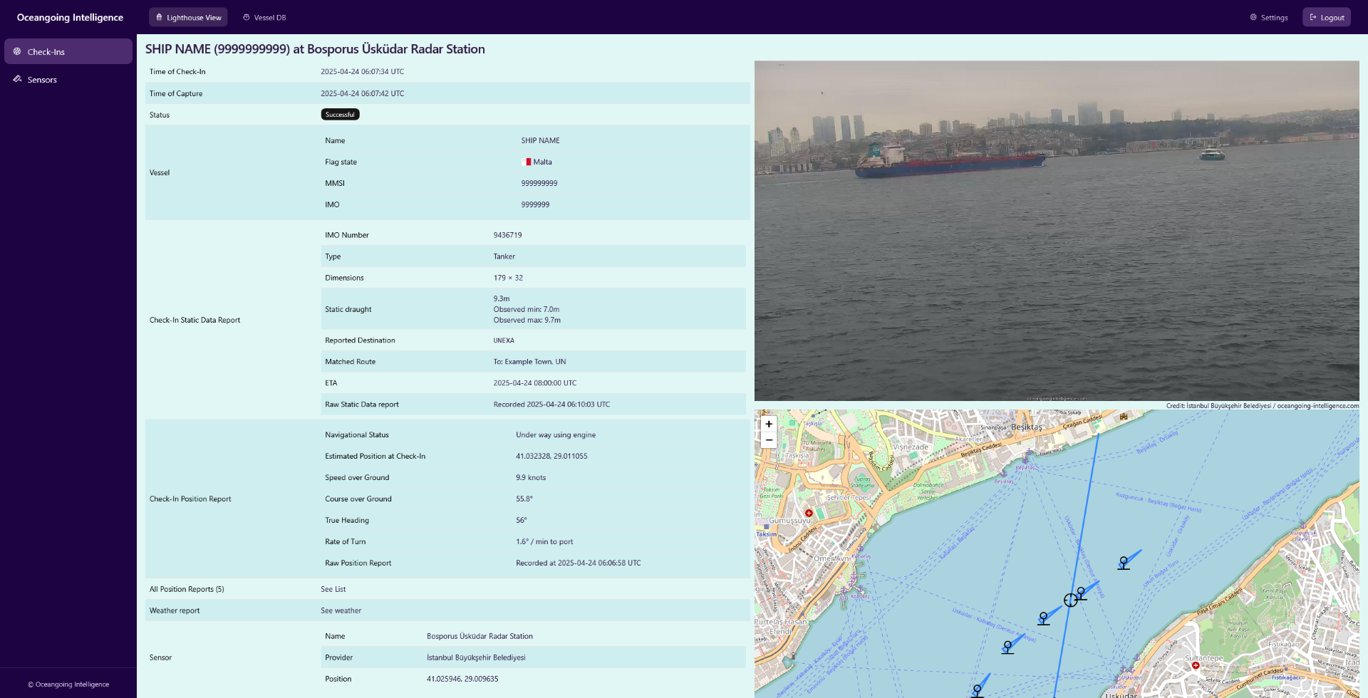
We use shore-side cameras covering maritime chokepoints, high-traffic waterways, and ports around the world. Every time a vessel is claiming to pass these sensors, automatic captures of the passage are made. We collect the AIS position and static voyage reports and connect them to the captures - this is what we call a Check-In.
Using this information and photographic evidence, you can:
- Confirm that a vessel was there.
- Visually verify that the vessel is the expected vessel.
- Validate AIS claims like vessel type, draught, or navigational status.
Over the years, we have built a database of more than 100,000 Check-Ins, allowing you to perform these investigations retroactively.
Validate your AIS Feed with Reality at Sea Level
Request a Demo Today
Frequently Asked Questions
Why use Lighthouse View if satellite imagery is available?
Satellite imagery has revolutionized our ability to track illicit offshore activities—like mid-ocean ship-to-ship transfers - but is often limited by its top-down, low-resolution perspective. Lighthouse View gives you a "ground-level" advantage by capturing the broadside of the vessel from shore - often revealing the hull markings, draught levels, or physical modifications that top-down satellite sensors miss.
How does Lighthouse View differ from OSINT ship-spotter databases?
Open-source databases typically rely on hobbyist photographers, which results in beautiful, high-quality images usually captured in fair weather and daylight. In contrast, Lighthouse View offers systematic captures of passing vessels 24/7, regardless of weather conditions. While these images are, at best, accidentally beautiful, they are correlated with the vessels' AIS signals — and guaranteed not to be uploaded by threat actors seeking to mask a vessel’s identity.
Features
Globe-Spanning Network
With sensors on four continents spanning major chokepoints, ports, and waterways we check-in hundreds of vessels every day.
Multiple AIS Sources
We are correlating data from satellite, terrestrial, and shipborne AIS sources from multiple providers for optimal coverage.
Searchable Database
Query vessels by IMO, MMSI, or name. Retrieve historical captures with AIS reports, timestamps, coordinates, and visual proof.
Real-Time Alerts
Get notified immediately when selected vessels are captured on camera. Or subscribe to automatically updated sanction lists.
Seamless Integration
Use Lighthouse View data in your own systems via our developer-friendly REST APIs.
Bring Your Own Sensor
Securely integrate your existing camera feeds into our network to profit from the same enrichment processes.


