Lighthouse View
Lighthouse View combines AIS data with automated shore-side camera captures worldwide — giving you visual proof of vessel movements, not just transmitted signals.
Reclaiming the Ground Truth
With terrestrial, satellite, and ship-borne AIS, we have more signals from the maritime domain than ever before. But malicious actors have adapted, poisoning the well with deceptive data:
- Identity Theft: Vessels “resurrecting” the IMO numbers of scrapped ships or hijacking the identities of vessels still under construction.
- Phantom Movements: Sophisticated AIS spoofing that creates entire “ghost” voyages.
- Draught manipulation: Pretending to be in ballast while actually being fully laden.
To detect these activities, a wide array of data sources, different technologies, and manual investigation is necessary. Lighthouse View provides the visual evidence you need to uncover the truth in key maritime areas.
How it works
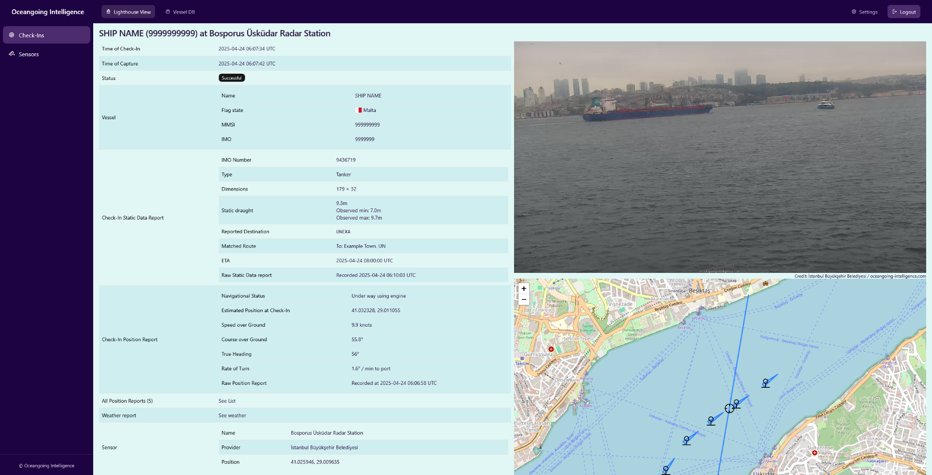
We use shore-side cameras covering maritime chokepoints, high-traffic waterways, and ports around the world. Every time a vessel is claiming to pass these sensors, automatic captures of the passage are made. We collect the AIS position and static voyage reports and connect them to the captures - this is what we call a Check-In.
Using this information and photographic evidence, you can:
- Confirm that a vessel was there.
- Visually verify that the vessel is the expected vessel.
- Validate AIS claims like vessel type, draught, or navigational status.
Over the years, we have built a database of more than 100,000 Check-Ins, allowing you to perform these investigations retroactively.
Validate your AIS Feed with Reality at Sea Level
Features
Globe-Spanning Network
With sensors on four continents spanning major chokepoints, ports, and waterways we check-in hundreds of vessels every day.
Multiple AIS Sources
We are correlating data from satellite, terrestrial, and shipborne AIS sources from multiple providers for optimal coverage.
Searchable Database
Query vessels by IMO, MMSI, or name. Retrieve historical captures with AIS reports, timestamps, coordinates, and visual proof.
Real-Time Alerts
Get notified immediately when selected vessels are captured on camera. Or subscribe to automatically updated sanction lists.
Seamless Integration
Use Lighthouse View data in your own systems via our developer-friendly REST APIs.
Bring Your Own Sensor
Securely integrate your existing camera feeds into our network to profit from the same enrichment processes.
